For many Aussies, pets aren’t just animals, they’re family. So, it’s no surprise that when it comes to hitting the road, taking your furry friend along is often part of the adventure.
So, which road trips in Australia are the most pet-friendly?
The team at ROLLiN’ wanted to find out which journeys truly cater to pets. We analysed 22 of Australia’s most iconic road trips, scoring each across eight key factors, including pet amenities, safety, comfort, and overall experience. The results reveal which road trips deliver the best experience for travellers and their pets.
The Most Pet-Friendly Road Trips in Australia
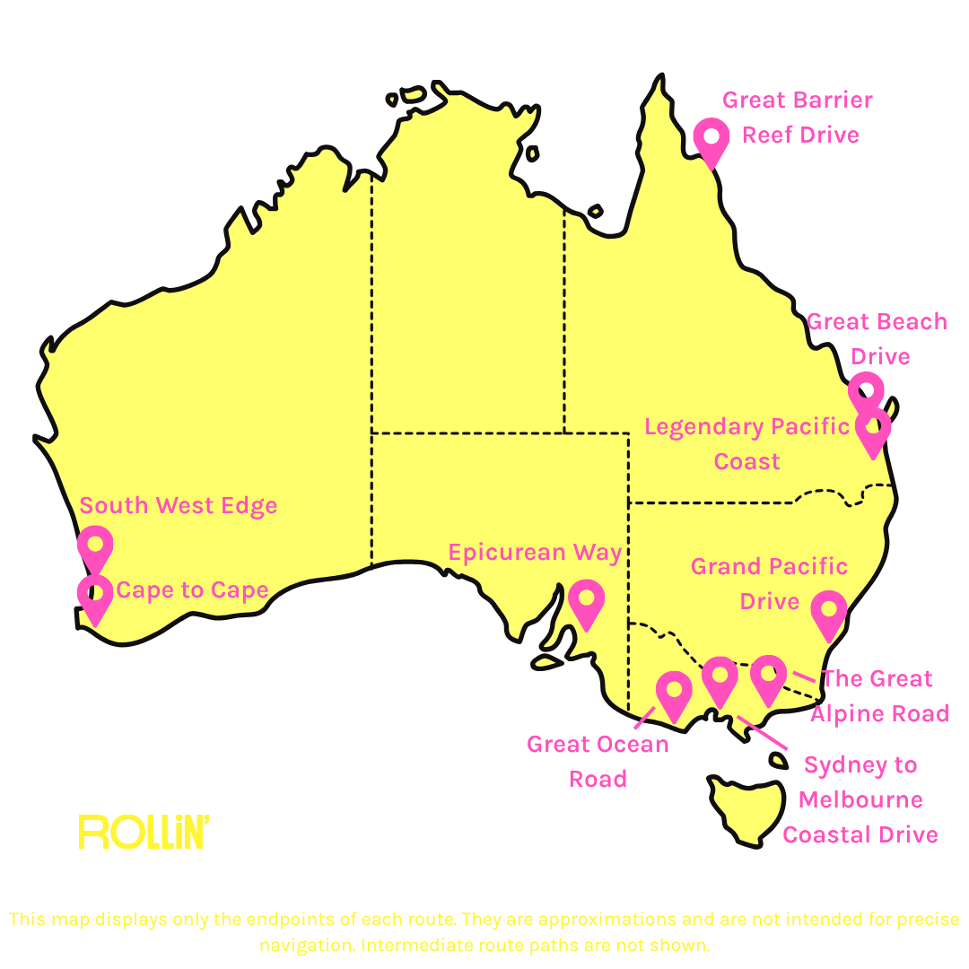
Cape to Cape in WA claims the top spot as Australia’s most pet-friendly road trip, scoring 79.2 out of 100. The 111km route from Cape Naturaliste to Cape Leeuwin has the highest density of dog parks and beaches (159.42 per 100km) and the most pet-friendly accommodation (30.62 per 100km). The route scores a perfect 100 on temperature comfort, making it ideal for pet travel.
Grand Pacific Drive, a scenic coastal route in NSW, follows closely, scoring 78.8 out of 100. This is driven by its top Experience & Shareability score, which includes 328 scenic points of interest and pet-friendly trails per 100km. This road trip also offers 57 pet-friendly eateries and 91 parks and beaches every 100km, making it ideal for pet owners who want a mix of adventure and convenience.
Rounding out the top three is the Legendary Pacific Coast, which stretches from NSW to QLD (72.9/100). It leads in veterinary clinic density (9.56 per 100km) in case of emergencies and offers excellent pet amenities. Unlike Cape to Cape or Grand Pacific Drive, it has consistent scores across all pet-friendly options, making it a reliable choice for road trippers.
The least pet-friendly road trips are Cairns to Cape York in QLD (55.1/100), Gibb River Road in WA (54.7/100) and Tasmania’s Western Wilds (53.3/100). They all generally offer fewer pet-friendly amenities, limited vet access, and lower experience and shareability scores.
The Road Trips Best for Pet Amenities
Zero scores may reflect either a genuine absence of this amenity along the route or a gap in available data. Remote and regional routes are more likely to reflect true absence.
To break it down further, we looked at the road trips that are the best for Pet Amenities. This focuses on routes that make it easy for pet owners to find places to eat, sleep, stretch, or just take a break with their furry friend.
Cape to Cape takes the top spot once again with a score of 86.8. This route boasts the highest density of pet-friendly accommodation, parks, and beaches. In fact, Margaret River has a reputation as one of Australia’s most dog-welcome tourism destinations with accommodation like Margaret House or Ohana B. Paired with frequent rest stops and over 20 pet-friendly eateries every 100km, this road trip offers travellers plenty of comfort, exercise and meals along the way.
Grand Pacific Drive comes in second (81.5/100), driven by the highest eatery density of all road trips, including KG Cafe in Kiama or Lou’s Place in Shellharbour. Grand Pacific Drive’s parks and beaches density is also the second-highest, with spots like Woonona Beach or Bulli Beach. Evidently, the Illawarra and South Coast regions are filled with dog-friendly cafes and restaurants.
Routes that venture deep into Australia’s outback and wilderness naturally offer a very different kind of pet‑friendly experience. Iconic journeys like the Red Centre Way (NT), Explorers Way (SA and NT), Savannah Way (WA, NT and QLD), and Gibb River Road score below 54, reflecting their limited access to pet‑friendly accommodation, eateries and dog parks. For pet owners drawn to these off‑the‑beaten‑track adventures, the appeal lies in wide‑open spaces and raw landscapes, just with the understanding that being well‑prepared and self‑sufficient is key.
The Road Trips Best for Pet Safety
Snake observation counts reflect both actual snake prevalence and the intensity of reporting activity in each region. Densely populated routes with active citizen science programmes record higher counts, while remote routes with low human traffic may underreport actual prevalence. Figures should be interpreted as comparative indicators within the index rather than absolute measures of snake density.
For pet owners, keeping your furry friend safe is a must, and in Australia, where snakes, spiders and other wildlife can pop up around every corner, it’s a factor you can’t ignore. That's why we looked at the road trips best for Safety and Risk. These are the routes where you’ll find plenty of vet clinics and minimal snake danger.
The Legendary Pacific Coast leads with a score of 71.5. Across the 858km stretch, it offers 9.56 clinics per 100km - the highest overall. The consistent string of regional towns between Sydney and Brisbane means emergency care is rarely far. Yet despite the route’s strong access to veterinary care, there were over 300 venomous snake observations every 100km between 2020 - 2025. For travellers, this means staying alert, supervising pets, and being aware of the closest clinic.
Cape to Cape ranks second, scoring 70.6. While there is a modest number of vet clinics, it also has one of the lowest snake observation densities at just 5.40 per 100km. Interestingly, the Great Barrier Reef Drive records a similar number of vet clinics, but almost 150 snake observations. However, the route balances access to professional care with a manageable wildlife risk.
Again, remote road trips like Gibb River Road, Nullabor Plain (WA and SA) and Tasmania’s Western Wilds all score below 60. This highlights the impact of limited veterinary clinics and where professional care may be hours away. Travellers with pets should consider these risks prior and plan for any potential emergencies.
The Road Trips Best for Comfort and Environment
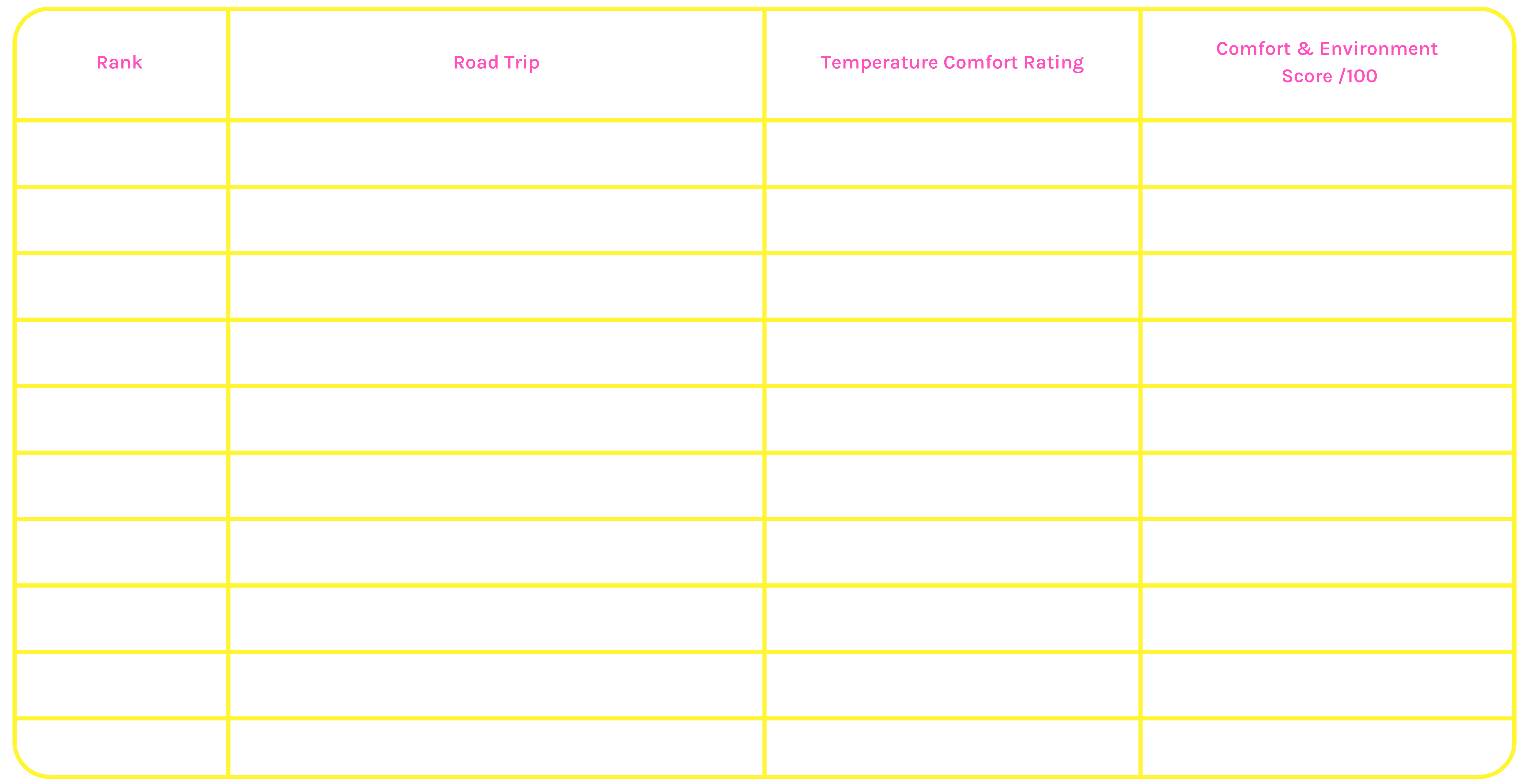
Keeping your pet at a comfortable temperature helps them stay safe, happy and stress-free. By looking at the top road trips for Comfort and Environment, it’s easy to see which route’s climate is best for travelling with a pet this Autumn and Winter.
Cape to Cape, Red Centre Way, Great Beach Drive (QLD), and the Legendary Pacific Coast all achieve the highest comfort scores - 76 out of 100. Seasonal average temperatures across all four routes fall consistently within the ideal pet comfort range (15–22°C), reflecting the moderate conditions that drive their top scores.
The rest of the road trips in the top ten all have temperature comfort ratings above 90, proving that many of Australia’s leading routes offer pet-friendly climates, particularly during the cooler months.
The Road Trips Best for Experience and Shareability
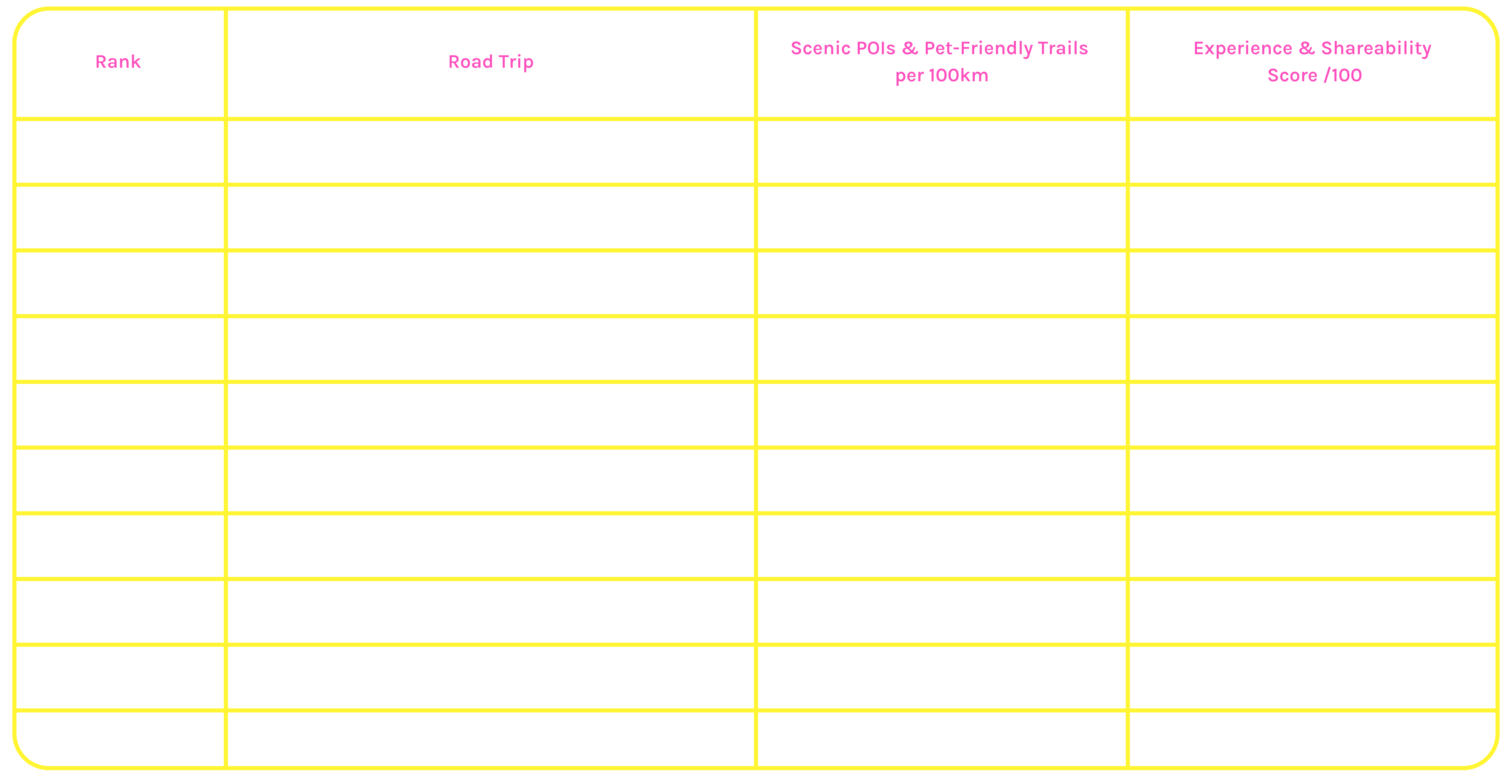
For pet owners who love capturing their adventures, the sights and trails along a road trip can make all the difference. Experience and Shareability looks at the number of scenic points of interest (POI’s) and dog-friendly trails, showing which routes are both visually stunning and shareable.
Grand Pacific Drive dominates, scoring 92.6 out of 100. It has an extraordinary density of 328 scenic places of interest and pet-friendly trails per 100km. This is unsurprising, given that the route offers dramatic sea cliffs, coastal lookouts and heritage landmarks - making it one of Australia’s most photogenic short drives.
Great Ocean Road (VIC) and Cape to Cape round out the top three. Both deliver an array of attractions, including beaches like Flinders Bay in Cape to Cape or Louttit Bay along the Great Ocean Road. Both road trips offer close to 150 scenic places of interest and pet-friendly trails every 100 km, making it an attractive route for pet owners.
Clearly, the most shareable road trips also tend to be the most pet-friendly, as they combine outdoor access and scenic variety with dog-friendly infrastructure.
Brendan Griffiths, Executive Manager at ROLLiN, comments:
“The team at ROLLiN’ know that travelling with your pet is often a non-negotiable, as many Aussies want to explore the country and create lasting memories with their furry companions. Ranking Australia’s most pet‑friendly road trips is about helping travellers enjoy unforgettable adventures with their pets, while ensuring everyone arrives safely at every stop.”
“Roadtripping with pets also comes with responsibilities. Having the right car insurance and following road safety rules is essential, not just for you, but for your pet too. Simple measures like securing your pet safely in the car, taking regular breaks, and keeping emergency supplies handy can make a big difference in ensuring a smooth, stress-free journey.”
About the data:
How We Built the Index
Twenty-two of Australia's most iconic road trips were assessed across eight metrics spanning pet amenities, safety, comfort, and experience. Each metric was measured within a 10km corridor along the cleaned route line and standardised per 100km of route length, ensuring fair comparison between routes of very different distances and excluding urban areas at each end of the journey.
Metropolitan areas were excluded using spatial buffers around major Australian cities and regional hubs: Sydney (50km), Melbourne (50km), Brisbane (40km), Perth (35km), Adelaide (30km), Darwin (30km), Hobart (20km), Canberra (20km), Cairns (15km) and Alice Springs (15km). Cairns and Alice Springs were included as exclusion zones because multiple routes originate there, and without exclusion, urban venues in those cities would inflate scores for routes that begin there rather than pass through them.
Each metric was scored using a sigmoid normalisation method that places every route on a comparable scale while preventing extreme values from distorting results. Normalised scores were multiplied by their category weights and summed to produce each route's final Pet Friendly Score. For snake risk, scoring was inverted so that higher observation density produces a lower score. No route scores zero on any individual metric, reflecting that every road trip offers some level of pet-friendly value even where data is sparse.
The Metrics:
-
Pet-Friendly Accommodation: Pet-friendly accommodation listings were sourced from publicly available pet travel directories and spatially matched to each route. Duplicate listings appearing across multiple sources were removed by coordinate proximity before combining. Coordinates are approximate, as properties were geocoded from name and location rather than exact street addresses.
-
Dog-Friendly Eateries: Dog-friendly cafes, pubs, bars and wineries were sourced from publicly available pet-friendly place directories. All three sub-categories were combined into a single eateries count. Wineries were included, given their particular relevance to wine region routes such as the Epicurean Way, Cape to Cape and South West Edge.
-
Dog Parks and Dog-Friendly Beaches: Off-leash dog parks and dog-friendly beaches were identified using OpenStreetMap and publicly available pet-friendly place directories. Two location types were included: formally tagged off-leash dog parks and beaches without a recorded dog restriction. General parks and nature reserves were excluded due to inconsistent dog access tagging in OpenStreetMap, where the absence of a restriction tag cannot be reliably interpreted as confirmed dog-friendly status.
-
Rest Stops: Rest stop locations were sourced from the National Freight Data Hub national rest area dataset, supplemented with Transport for NSW data for NSW routes. Only passenger vehicle-accessible stops within each route corridor were included, with heavy vehicle-only facilities excluded.
-
Veterinary Clinics: Veterinary clinic locations were extracted from OpenStreetMap and mapped within each route corridor.
-
Snake Risk: Venomous snake observations were sourced from the Atlas of Living Australia, covering January 2020 to December 2025. Only human and machine observations were included, with each record treated as a single encounter event. Observations were then mapped within each route corridor.
Snake observation counts reflect both actual snake prevalence and the intensity of reporting activity in each region. Densely populated routes with active citizen science programmes tend to record higher counts, while remote routes with low human traffic may underreport actual prevalence. Figures should be interpreted as comparative indicators within the index rather than absolute measures of snake density.
-
Temperature Comfort: Seasonal temperature comfort was assessed using SILO gridded climate data for March to August across 2020 to 2024, capturing the autumn and winter travel window when conditions are most suitable for road tripping with pets.
Mean daily temperature was calculated at sample points every 25km along each route and scored against a comfort model that peaks at 100 for the ideal pet travel range of 15 to 22 degrees Celsius, declining toward extremes in both directions. This range represents a moderate zone cool enough to prevent overheating during stops and walks, and warm enough to avoid cold stress.
Route scores represent the average comfort across all sample points, capturing temperature variation along longer routes rather than treating each as a single uniform value.
-
Scenic POIs and Dog-Friendly Trails: Scenic points of interest were extracted from OpenStreetMap, including viewpoints, lookouts and natural features such as peaks, cliffs, waterfalls and cave entrances, as well as heritage landmarks including monuments, ruins and archaeological sites.
Indoor and managed venues such as museums and tourist attractions were excluded as these are generally not accessible to dogs. Dog-friendly walking trails and hikes were sourced from publicly available pet-friendly place directories and matched within each route's corridor.
Data Limitations
OpenStreetMap is a community-maintained dataset with generally strong coverage in urban and peri-urban areas, but coverage may be incomplete in regional and remote corridors. Pet-friendly place directories used for accommodation, eateries, dog parks and trails rely on user-submitted or operator-submitted listings, meaning coverage is not uniform across Australia and skews toward populated coastal regions. Remote and regional routes may have legitimate venues that are not captured in any available directory.
Several remote routes record zero on one or more metrics. Where zeros appear, they may reflect a genuine absence of that amenity along the route or a gap in available data. Remote and regional routes are more likely to reflect true absence. The sigmoid normalisation method ensures zero-scoring routes are not penalised to zero in the final index.
Pet-friendly designations for certain location types, including beaches and off-leash areas, are based on the absence of recorded restrictions in publicly available datasets rather than direct verification. Travellers should confirm access conditions locally before visiting, as rules and restrictions may vary by council, season or time of day.
Insurance issued by Insurance Australia Limited ABN 11 000 016 722 trading as Rollin’ Insurance. To see if a product is right for you, always consider the Product Disclosure Statement. Product Disclosure Statement and Target Market Determination are available from rollininsurance.com.au.